
ORIENTATION
Terrain orientation
When going on a trip, you should not rely only on GPS systems. Gadgets tend to fail or get lost, and in inclement weather they are not able to establish contact with satellites to determine the location. Finally, where there are no street names, even pinpointing your location will not help you if you do not have topographic landmarks.
Always take a compass, extra batteries and a map with you as a reserve variant.
Even before you find yourself in an uninhabited area, it is worth exploring it on the map. You need to find out what is within a radius of 20-30 km from where you are going. If you get lost, you will be able to navigate by the location of lakes, mountains, sea shores and other natural objects.
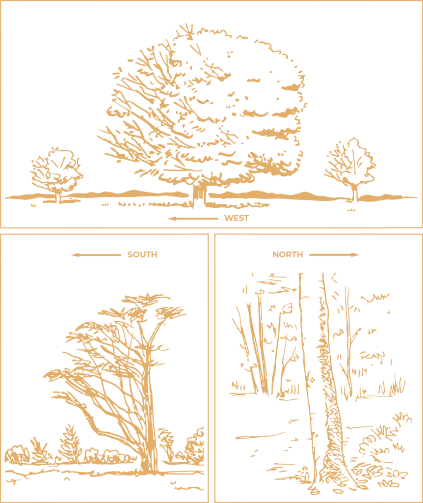
Nature provides many clues about your location. Since most winds blow from the west, trees and shrubs tend to have more foliage on the east side. And there are more branches on the south side, since it is she who receives the maximum sunlight due to the tilt of our planet. Moss grows best in the shade, so it is more common on the north side of trees. This hint should be used more carefully than others: an individual tree can be shaded by neighboring ones. Make sure you see the big picture first and don’t jump to conclusions.
Sun orientation
For thousands of years, people have been using celestial objects as navigational tools. If you have studied the map and generally figured out the features of the terrain, you can find your way to a safe place with the help of the closest star to us – the Sun. Just watch it move. The easiest way to track the movement of the sun is to determine in which direction you are casting the shadow. As the sun rises in the east, it casts a shadow to the west in the morning. In the afternoon, when the sun begins to move westward, your shadow will point eastward.
It is difficult to use this technique at noon, since the sun, which is high overhead, gives almost no shade.
Using an analog clock, you can easily determine the main directions (north, south, west, east). Raise your hand with the clock as if you want to determine the time, then turn it so that the hour hand “looks” at the sun.
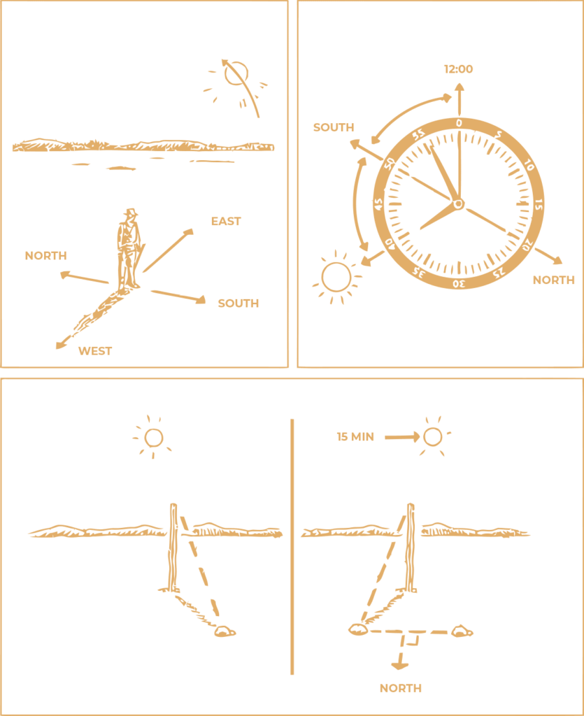
The direction to the south is indicated by a point on the clock which is halfway between the hour hand and the 12 o’clock position. If it is not possible to determine the time of day, make an impromptu sundial and use the movement of your shadow for orientation. To do this, stick a stick into the ground and place a stone in the place where the shadow from it ends. Wait 15 minutes and do the same with the new position of the shadow. Draw one line between the two stones and the other perpendicular to it. The end of the perpendicular line farthest from the stick indicates the direction to the north.
Orientation by the stars
Orientation by the stars has helped countless sailors, pirates and explorers reach distant shores and treasures. Any traveler will be able to determine the cardinal points even in pitch darkness. This is good news for those who move after sunset.
The choice of stars in the night sky to navigate depends on your geographic coordinates, season, cloud cover and time of night.
In the Northern Hemisphere, a very convenient landmark is the North Star, by which you can determine the direction to the north. Since it is near the North Pole, its position in the sky is almost unchanged. This is not the brightest star in the sky. To find her, you must first find the constellations closest to her: Ursa Major, Ursa Minor and Cassiopeia. It is located in a straight line with the two outer stars of the Big Dipper bowl. If we take the distance between these two stars as one, Polaris is five such units from the last of them, and also approximately halfway between the Ursa Major and the middle star of the constellation Cassiopeia, which has the shape of the letter W. Polaris is also the last star in the handle of Ursa Minor.
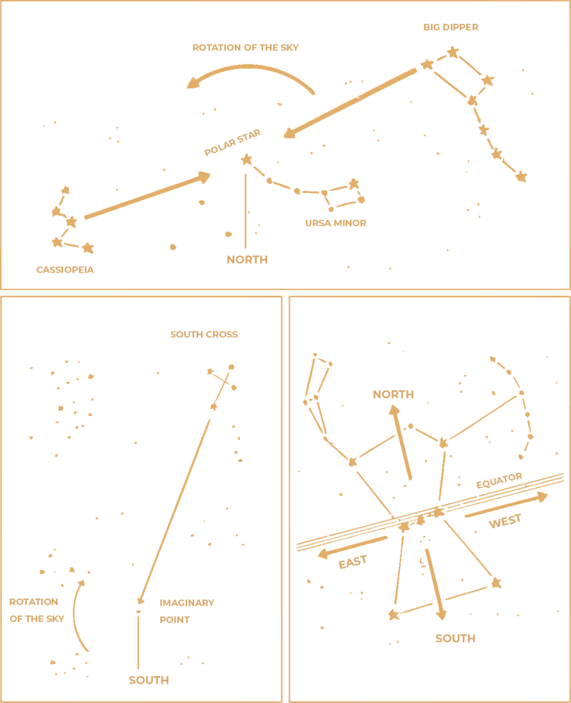
There is no such reference star at the South Pole, but in the Southern Hemisphere, the direction can be determined by the position of the Southern Cross constellation. Draw an imaginary line from the brightest star in this constellation to the opposite star (of the two axes of the cross, this is the longest). If we consider the length of this axis as a unit of distance, the South Pole is located, when viewed in the direction of the brightest star, at a distance of four and a half such units. Find Orion’s Belt at the equator. The three horizontally located stars that make up this belt lie on the east-west line; Orion’s “torso” points to the north, and the “legs” to the south.
Magnetic navigation
The compass is a useful navigational tool and, like all such much needed instruments, is made from materials that can be obtained from the many available sources. Electrical wires can be found in radio speakers, flashlights, and in cars. Batteries are used in a wide variety of devices. A roll of duct tape is a must-have in the car. But to get a needle or a thin long steel arrow, if you did not put it in your supply, you will have to try.
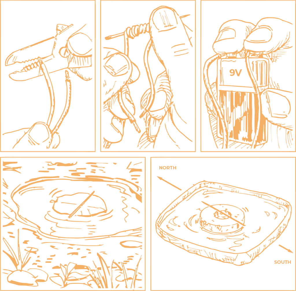
With a few simple steps, you can magnetize a steel needle or piece of wire from a fence and use it just like a regular store-bought compass. The operation of the navigation device is based on the action of the Earth’s magnetic field, or “magnetosphere”, on the arrow, setting it in a certain direction. The electric charge causes the ions to collect at one end of the arrow, and if nothing interferes with it, it will automatically show direction north-south.
It is enough to magnetize only one end of the needle, but keep in mind that such a small and thin device is difficult to work with. Use a needle for only the most general information to find the axis showing north and south. To determine exactly where each end is directed, you will need to use some other type of orientation to natural objects.
The north direction of the manufactured compass actually shows the north magnetic pole of the earth, which is located about 2,000 km south of true north – the geographic N Pole of the earth. Therefore, the readings of improvised navigation devices should be supplemented, whenever possible, with maps. Only in this way you will have a complete picture of the direction of travel.


